A rather lengthy adventure post by Rusty

The Colorado Trail is one of the premiere hiking trails in the country, and at 486 miles, it’s about as long of a thru-hike as Karen is willing to do at one time. But neither one of us has hiked at this elevation before, let alone for an extended period of time. Since we were in the neighborhood already this year, we thought we’d try out a couple of sections to see how we do before we attempt a thru-hike of the Colorado Trail… maybe as early as next year.
We’ve been living in our van for the past six weeks at elevations well over 5,000 ft, and have done some day hikes in New Mexico and Colorado as high as 9,200 ft. Now was our best opportunity to try some overnights and higher elevations, putting both the trail and our capabilities to the test.
The Colorado Trail was completed in 1987. It’s divided into 33 sections (convenient for maps and trail descriptions) running from Waterton Canyon southwest of Denver to Durango. The 3,100 mile long Continental Divide shares 234 miles of the Colorado Trail, on its way from Mexico to Canada. Most of the Colorado Trail is above 10,000 ft, including Coney Summit, which is the trail’s highest point at 13,334 ft in the San Juan Mountains to the south. But at the north end of the trail, near Denver, the elevation is only 5,520 ft, which is where most thru-hikers start in order to more gradually adjust to the diminished oxygen levels at elevation and avoid that nasty (and sometimes deadly) altitude sickness.
But we’re traveling south-to-north right now and we’re already acclimated, so we picked higher elevation sections 21 and 22, both of which are accessible from the Spring Creek Pass trailhead, to hike first. Then, as we travel north toward Denver, we’ll try a lower elevation hike on section 3. It was a plan.
~~~
We said goodbye to our friends, Mary and Chris, in Pagosa Springs and drove 96 miles along some very twisty-turny mountain highways to Spring Creek Pass. The elevation there is 10,889 ft. We checked our gear and packed our backpacks with food and supplies for a two-day excursion, made a nice dinner, abstained from our usual evening glass of wine, and turned in early.
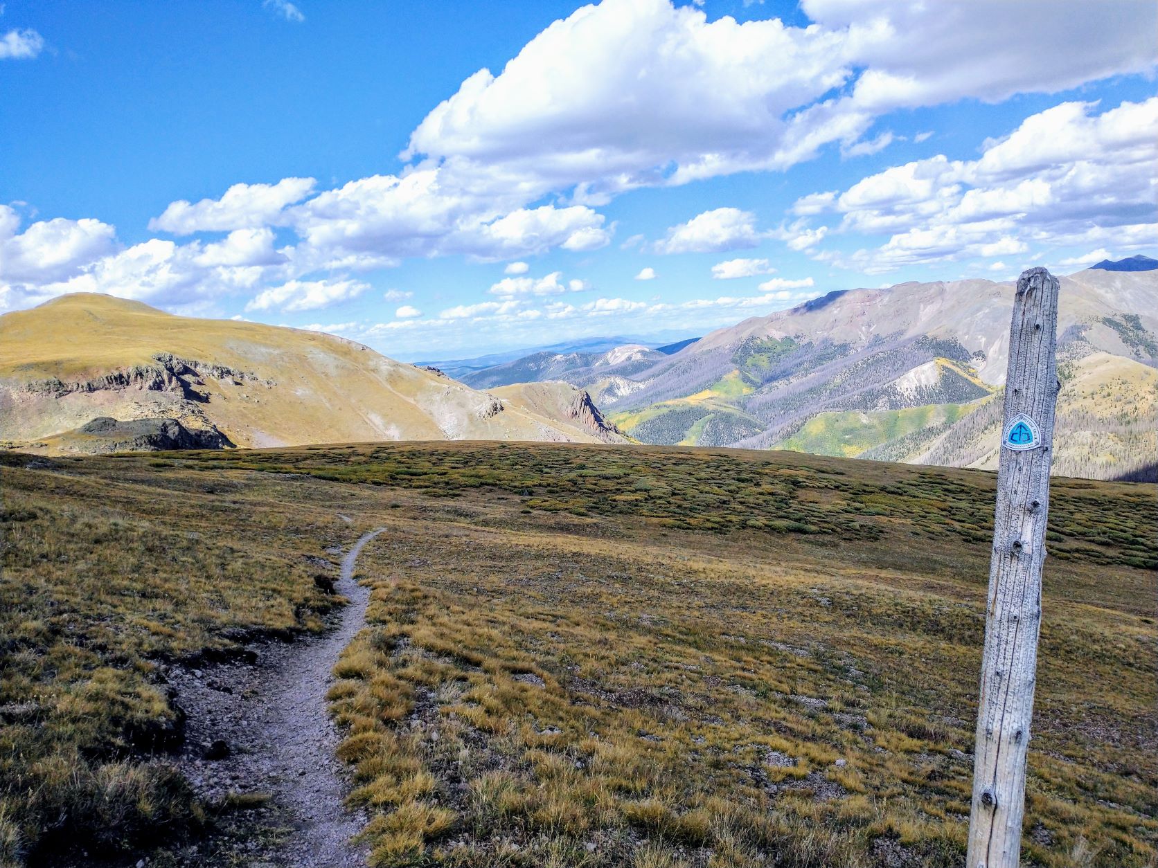
Eager with anticipation, we were both up before dawn. It was a chilly 38 degrees outside the van, but a comparatively toasty 53 inside. Coffee and breakfast and other miscellaneous chores later, we were headed southbound on the section 22 trail by 7:30 am. A pretty good start for two old grey hikers.

Starting Segment 22 
Dead spruce trees dominate the forest 
Cairns mark the way


The first 2 ½ miles was uphill along a dirt service road, and while the trail isn’t difficult here the steady climb had us struggling a little for air. Our path meandered gently through a spruce forest that had been recently decimated by a spruce beetle infestation. It is depressing to hike through such pain and death, but the spruce beetle is indigenous to this forest and this as a natural cycle of death and rebirth for the forest, much like wildfires.
We climbed out of the forest onto Jarosa Mesa and 12,000 ft. It was a treeless area with intermittent fields of rock that we discovered were home to the Yellow-bellied Marmot and the cute little American Pika. They chirped a high-pitched warning to their comrades as we walked by. The rocks made the trail harder, but at least it was flat.
As we descended the mesa, we saw a communications tower on the imaginatively-named Hill 71. The trail skirted around the base of the hill and we saw signage that indicated this was a Bureau of Land Management facility. Then we climbed again into a forested area full of dead spruce, stopping occasionally to catch our breath.

Yellow-bellied Marmot 
Resting on Jarosa Mesa 
The trail follows several service roads on this section


Eventually, we came to a valley that sees lots of flooding each spring, but right now it appeared to be completely dry. A group of Americorp volunteers was rerouting the trail around the boggiest areas and constructing log foot bridges over the now-muddy stream beds. There was supposed to be a spring here, but we didn’t see it. We thanked them for their efforts and continued on up the other side of the valley, back into the distressed forest.
We’d done only 9 miles so far, but Karen was getting tired. Eight miles at this altitude, with a good amount of climbing, was beginning to feel like 16 miles. We began looking for a clear spot to pitch our tent, but there were too many dead trees around that could topple at any time in wind or rain. So we continued slowly for another 0.6 miles until we reached the top of this hill and more open and flat terrain.
Karen was happy to stop, but now we needed water. Hiker comments on Guthook Guides, our trail GPS app indicated that there was water up ahead, marked by a cairn next to the trail. So we set up camp and I took off with our empty water bottles. The trail climbed up another 400 ft over three quarters of a mile to a ridge. When I got to the cairn, I started to explore downslope. I found indications of water erosions, but no water. I Returned to Karen, disappointed with our app and the less-than-helpful comments from previous hikers.
I retraced our hike back down the mountain to where the Americorp volunteers were still working. And looked dejectedly at the muddy trickle running down the stream bed. Before I could start scooping water, however, they told me that there was another spring nearby, just 60 ft along a game trail through the dense brush. Hallelujah!
I collected four liters of clean mountain spring water, thanked the trail volunteers and scampered back up the hill Karen and our campsite. Now water-rich, we could cook dinner and make it comfortably through the night.
It was clear and getting cold, but it was beautiful here at 12,028 ft. Overnight, we heard bull elk bugling in search of a mate and coyotes yelping as they chased their prey. The stars too were amazing!
The next morning was frigid and we were reluctant to get out of our sleeping bags and tent. We finally got packed up and back on the trail just after 9am for the hike back to the van. Thankfully, there was more downhill today and we knew where to find water.

Everything is turning as temperatures dip 
Red Cloud Peak in the distance 
Storm clouds begin to chase after us


Halfway back, clouds started forming in the distance and began to drop rain. The air is dry and some of the small rainstorms weren’t even reaching the ground. We stopped for an early lunch before noon and watched the clouds and rain move past. We were intermittently warm and cold as the sun and clouds and wind played tag.
With only about 2 miles to go it started to sprinkle on us. Another half mile, the rain picked up and the wind made it cold. There was a little thunder in the distance. For about 5 minutes, rice-sized hail was added to the mix.
Soon after, the rain began to ease up and stopped altogether with a half a mile to get to our van. The trail was a bit muddy now, and as it began to descend more steeply down to Spring Creek Pass. By the time we got back, we were wet, muddy and tired. But it was good to be home.
The monsoon season has been especially strong this year with lots of afternoon thunderstorms and even flash floods throughout the southwest, reaching all the way into Colorado and Wyoming. We’ll have adjust our gear somewhat if we’re to be prepared next year for inclement, and even dangerous, weather at this altitude.
~~~
Being in the van again has its advantages. We were up before dawn the next morning, drinking expresso and feasting on fried potatoes and eggs, despite the cold temps outside. We got onto section 21, headed northbound, at 8:30am and planned to hike in about 10 miles, camp and return the next day.
The first two miles were pretty steep, first in a dense forest and then above the tree line. We stopped every few hundred feet to catch our breath and Karen made good use of the Boost oxygen bottle I’d gotten for her to try out. The trail began to climb a deep groove at the bottom of a rocky ravine. This gave way to a small boulder field we had to scramble through as we climbed to the edge of the Snow Mesa at 12,270 ft.

Hiking a
rocky ravine up to the Snow Mesa
The narrow trail trail disappears into the vast Mesa 
A skull adorns a cairn on the Snow Mesa


The Snow Mesa was breathtaking! This is the largest expanse of alpine tundra in the lower 48. We walked 3.4 miles, from cairn to cairn, through a dreamy, grassy plateau that faded into the distance, with distant mountains towering even higher in every direction.

Distant peaks surround us everywhere 
An unlikely, but pristine, lake at 12,000 ft


The trail here was very narrow and mostly flat, with the exception of a few ups and downs over now-dry stream beds marking where winter snowmelt had eroded away the earth in its search for lower ground. A trio of young hikers and two bicyclists passed us on our way, but otherwise we felt completely alone and isolated from the rest of the world. At the end of the Mesa, the trail descended a bit to pass a small, but beautiful mountain lake. We were a little over halfway through our day’s hike.
Our path began to climb now along the very steep slopes of a large bowl up toward a ridge, nearly 500 ft above us. The trail here was still extremely narrow, sometimes going over grassy slopes and sometimes over boulders and rockslides. As we climbed higher, Karen’s vertigo took hold so she held onto my pack for balance while we slowly made our way around.

Narrow rail on a steep slope 
Rusty at 12,772 ft 
The trail crosses a steep boulder field ahead


We crossed paths with two more hikers, one of whom was having severe altitude sickness forcing them to turn back. We persevered though, and finally made our way to the top of the ridge, which topped out at 12,772 ft, the high point for this section and the highest either of us have hiked.
The views from the ridge were epic as we hiked through an enormous landscape that dwarfed anything we’d encountered before. We felt really good about conquering the last bit of trail to get here.

Descending the high ridge 
The trail is easier for awhile

The next mile and a half along and over the ridge was fairly easy and the views continued to amaze, but then the trail started following very steep slopes again around the mountains. This forced us to greatly slow our pace and concentrate exclusively on our footing lest we end up sliding or tumbling down a few hundred feet. This lasted for 1.4 miles until we reached a saddle and began our last decent below the tree line.
After several switchbacks and lots of loose gravel, we made our way to a grassy valley at 11,484 ft, adjacent to Middle Mineral Creak. We saw seven deer grazing there, but they scattered as we approached.
After setting up camp and getting water from the creek, we prepared our dinner of Knorr’s Spanish Rice and tuna, savoring every bite after an exhausting hike. We finally crawled into our tent well before sunset. We expect that this is going to be a cold night.
~~~
Down in a valley, morning light came late. That, combined with a chilly morning, always leads to a late start for us. The climb back out of the valley was uneventful, but I know Karen was dreading re-hiking the steep slopes that we’d done yesterday. We took our time, and Karen held onto my pack for support.
Before we began the climb back to the high ridge, we stopped in another grassy saddle for an early lunch. The sky was mostly clear, and the sun at this altitude can quickly get hot. But after a cold night and a cool morning, we’re loving it and stretch out on our sleeping pads to soak it in.

Obligatory selfie 
Snow Mesa in the distance as we climb the high ridge a second time


We still have 7 miles to go, so after a few minutes we reluctantly get back on trail to begin our last big climb of the day. The views are still spectacular, but we’re starting to see thickening clouds and rain is falling on some of the distant mountains. We pass several hikers as we traverse the ridge and then the steep bowl. They’re all headed northbound. Many of them had previously been hiking on the Pacific Crest Trail before the California fires closed down that trail.
The trek across the Snow Mesa is stark and beautiful, especially with the growing clouds and threatening rain. We would normally pick up our pace, but Karen is exhausted after 3 ½ days of challenging trail, so we plod onward hoping the rain stays put in the distant mountains.

Last trek across the Snow Mesa 
Distant rainstorms threaten 
Descending the boulder field Into the rocky ravine


Eventually we reach the edge of the Mesa, make our way over the edge and through the boulder field and ravine. Then through the tree line and two more miles downhill to Spring Creek Pass. As we near the end of our hike, we spot our white van through the trees sitting there where we left her, beckoning us home.
This was a very challenging section, but we learned that we can do it. Next time, we’ll add some new gear for protection from the elements, including UV sunglasses, better sunhats, and maybe even a mylar thermal survival blanket. Some micro spikes for better traction on loose mountain trail might not be a bad idea either.
~~~
The next day, we left the trailhead and drove to Gunnison to resupply and get gas, before driving on to Section 3 at the Rolling Creek trailhead, 250 miles northwest toward Denver. The last 8.5 miles is along terrible washboard gravel and dirt roads. We find our trailhead as sunset fast approaches, dig ourselves a cathole, eat a late dinner, and turn in much later than we’d planned.

Hiking in Segment 3 in a healthy, low-elevation forest 
This pine doesn’t like being used to blaze the trail


Hiking Section 3 of the Colorado Trail provided us with a better idea of the variety of terrain on the CT, including a good comparison with the high-elevation alpine areas. Here we hiked a short 4-mile section in-and-out through mixed pine, spruce and aspen forest over fairly gentle hills. The trail was well maintained and there was plenty of available water. This will be a great place to start our hike in the future and build our stamina before we get to the hard parts.
~~~
This is the first major trail that we’ve “test-hiked” before diving right in. It’s certainly been a challenge, but we think it was well worth the extra knowledge and experience we gained.
If we attempt a thru-hike next year, or the year after, we’ll definitely start at the north end near Denver. And, we’ll likely start sometime in mid- to late-July for more dependable water and warmer nights. In all, we think it should take us 40 days to hike, more or less, depending on resupplies, weather, and our need for zero-mile recovery days.
Sounds like a plan!
Fantastic Recount of a difficult and resplendent test-hike. Just the read through made ME feel like an ADVENTURER! Stay safe and keep it coming!! Mike S.
Love you both and very proud of you!!! Sounds like a huge hike!
Sounds wonderful; good going Karen!
Karen and Rusty,
I don’t use the word amazing easily, I believe it is misapplied to more ordinary things, but you two are amazing. I was holding my breath for you while reading this excellent account of a challenging trek in a land that has no forgiveness in it’s makeup. I send you good thoughts and encouragement in your future forays.
PS the citrus is shaping up nicely after a concerted effort to fight the greening and bolster our old trees. We have also planted 17 new Hamlin’s and Parson Browns resistant to the disease. Next time you’re in our neck of the woods you must stop in.
Rick
Thank you, Rick. That is high praise, indeed. We try to be honest in our retelling. Congratulations on your successes with the orchard! We look forward to seeing it and tasting the fruits of your labors when next we travel through your neck of the woods.