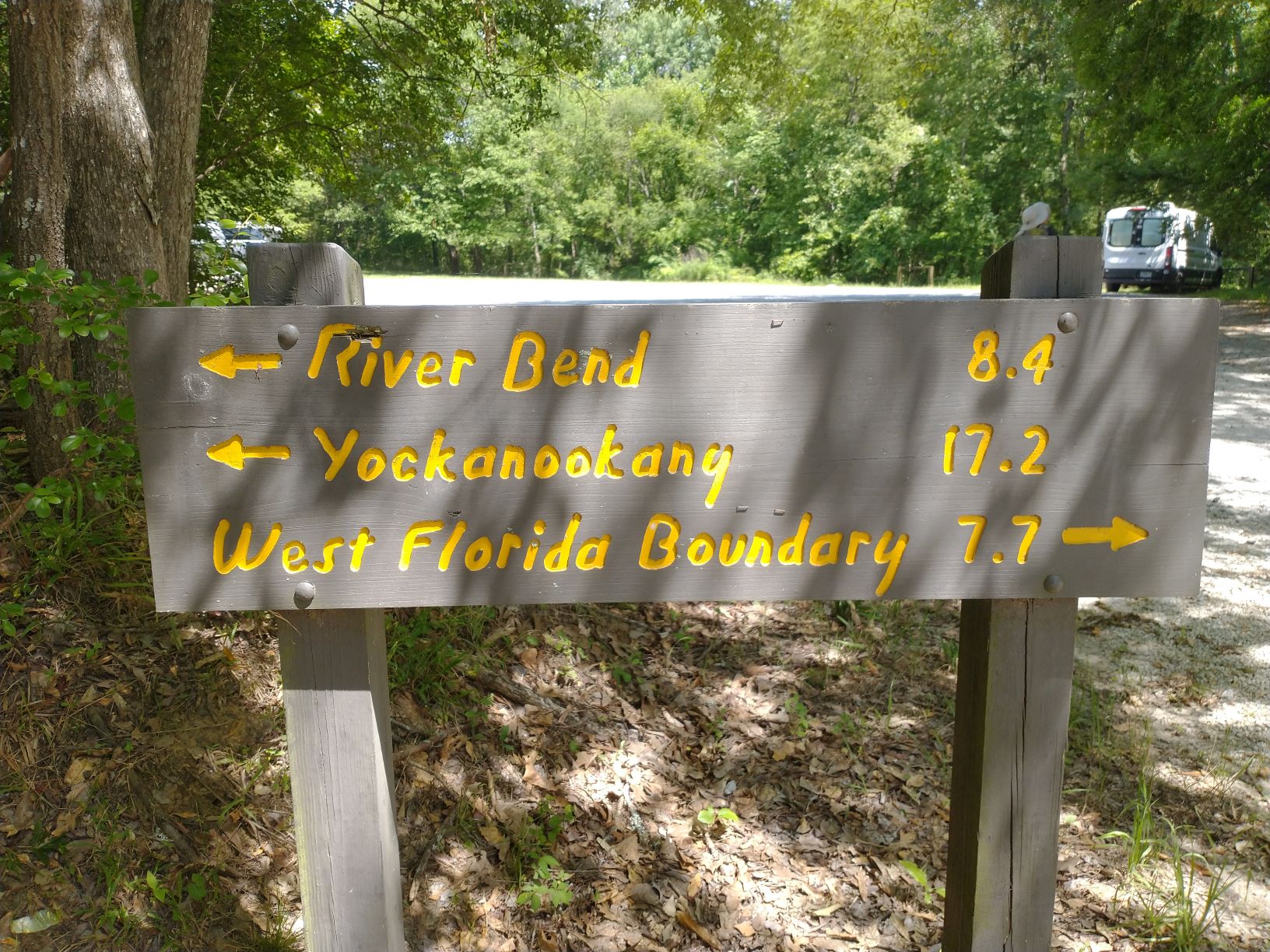
We left Vicksburg the morning of May 27 and drove an hour to the Yockanookany Section, which was supposed to have 26 miles of linear hiking trail with five trailheads for access. After Rocky Springs, we now expect it may be much longer.
We arrived at the southern terminus – the West Florida Boundary, which marked the edge of an old Spanish territory – and struck out. We were expecting the worst, after the hikes at Rocky Springs, but it was quite nice. The trail was clear, through mostly mixed forest. There were only a few blow-downs as it meandered over gentle ups and downs and along the Ross Barnett Reservoir. After hiking north just under 4 miles, we heading back to the van smiling all the way.

The trail was very nice here, with white blazes and good weather 
There was some road walking here on the Parkway with good views of the reservoir


After some cool water, we headed to the next trailhead at the Route 43 crossing, made supper and turned in. Then the fireflies started. They were synchronous fireflies. We’ve never seen so many fireflies flashing so much at the same time. It was mesmerizing. (We tried to take a video to share on the website, but they were too faint for our camera to capture.)
It was supposed to rain the next day, so we took some time off to rest and catch up on our writing. The day after, we headed south from Rt 43 to connect with our end point from our hike two days ago. The trail was just as nice as before, with only a few blow-downs and rickety boardwalks. There was definitely more maintenance going on here and even a couple new foot bridges strong enough for horses. Most remarkably, we were passed by at least twenty trail runners, and saw some equestrians. It was Saturday and we were close to Jackson and the reservoir. This gave us hope that the trail might be better from here on.

Rt 43 trailhead where our van patiently waited for us 
The trail slipped under the Parkway to the other side… 
…and this lovely artwork was waiting. 
A bit of erosion control on the trail


After we got back to the van, we rested and ate before continuing north from the Rt 43 trailhead. Unfortunately, it was nothing like the trail going south. It was now overgrown with thorny brambles and the footbridges and boardwalks were in sorry shape. The trail runners and equestrians were gone, and there was obviously no maintenance here for at least the last several years. We lost the trail a couple of times and picked our way very slowly through very tough terrain. The condition of the trail was actually so disheartening to us that after just 2.3 miles, when we exited the forest to detour around a large ravine and stream, we decided to call it a day and just road-walk back to the van.

Very wobbly foot bridge 
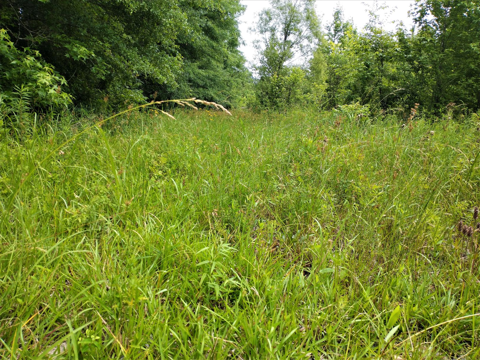
The trail just disappears into this waist-high grass. We stop here.

We then headed for our next trailhead 7 miles up the road, Cypress Swamp and Riverbend, where there were supposed to be flush toilets, potable water, and possibly a place to park overnight. At Cypress Swamp we found the trailhead on the west side of the Parkway, but didn’t venture in. There was also a half-mile nature trail on the east side with a boardwalk through an impressive cypress and tupelo swamp. It was barricaded, supposedly due to storm damage, but the boardwalk was in good shape. We hopped the fence and explored anyway
A half-mile up the road, we found that the Riverbend picnic area was closed and barricaded too. The water was shut off and the bathrooms were locked. Our hopes for a decent overnight location dashed, we drove to the last two trailheads of this section, Choctaw Boundary and Yockanookany. We didn’t like the looks of Yockanookany, so we backtracked 2.5 miles to Choctaw Boundary. It had better parking and a place we could dig a latrine out of site of the Parkway. After two hikes and trouble finding a place to overnight, we were both exhausted and after cleaning up, crawled into bed before dark.

Interpretive sign 
One of many broken bridges 
The trail is almost impossible to see 
A very rare official trail marker 
A more common ribbon marking the trail…if you can spot them


The next day, on May 30, we were on trail by 8:30am heading north to the northern terminus of the Yockanookany Section. It was supposed to be a short hike, but the trail was in sad shape. The forest here, between the Parkway on one side and farmland on the other, was only about a quarter mile wide so we couldn’t really get lost. Still, we lost the trail several times at blow-downs and streams. We ended up at a road crossing where the trail appeared to cross into thick, waist-high grass between some old growth and a newly planted forest. We opted not to wade through the likely tick-infested area and road-walked the parkway for a while.
Half a mile later, we saw another place where the trail exited the forest onto the parkway, detouring around a large stream, then re-entering the forest. I decided to follow the trail north, but Karen was tired and tired of the trail conditions, so she continued to road-walk. The trail was still very hard, but I didn’t lose it for the next half mile and arrived at the northern trailhead, Yockanookany, where I found Karen sitting at a picnic table waiting for me, having arrived 10 minutes earlier. After a short rest and snack, we road-walked back. By trail it was 3.2 miles, but by road, it was just 2.5 miles. Now we knew why the website was miscalculating the trail distances, using only the road mileage.
It was still early by the time we got back to the van, so I decided to hike back south a few miles. Karen was beat and needed some downtime, so she stayed with the van. The trail south was a little better, but only just. The path was faint, but there seemed to be more red ribbons left by equestrians. There were lots of blow-downs, one of which fell right through a footbridge over a large stream. I lost the trail several times only to find it again after bushwhacking ahead keeping an eye out for a red ribbon to the left or right. After 3.8 miles, I reached a road crossing and finally turned back. For some reason, seeing the trail now was harder than it was earlier. I think it was the light. I eventually arrived back at the van, 3 hours and 7.6 miles later.
Karen was just waking from a nap, her eyes a little puffy and her recently brushed hair forming a large silver halo around her face. I described my hike to her and showed her my pictures. She was proud of my effort. After our evening meal and clean-up, we ran out of water in our main tank. We still had spare water in the back, enough for another day or two, but our options were narrowing for finishing this difficult section with the supplies we had on hand.
We were up early on Memorial Day to try to hike the last middle bits of this section, north and south of the Cypress Swamp trailhead. The trailhead was on west side of the parkway, opposite the nature trail and boardwalk through the Tupelo and Cypress swamp. But the forest over there looked pretty bad, apparently from the tornados that came through last year, so we proceeded with trepidation.

A beautiful, but small cypress and tupelo swamp 
The Cypress Swamp trailhead look pretty uninviting


We got in only a couple hundred feet and we saw where crews had started to cut down endless the blow-downs. It was insanely thick and there was no getting through here without chainsaws and machetes. After just 20 minutes, we called it quits and abandoned this part of the Yockanookany Section forever.
I visited Vicksburg many years ago; it is a old, lovely and fitting place for solders.
Very true. Even though we could see the gravestones into the distance, the cemetery was still closed due to Covid we guess, as was the inside portion of the Cairo Museum. But it was good to be there anyway around Memorial Day.