Bears Ears National Monument holds special value and significance for several local Native American tribes: the Navajo Nation, Hopi, Ute Mountain Ute, Ute Indian Tribe of the Uintah and Ouray Reservation, and the Pueblo of Zuni, all of which have ancestral ties to this region of southeast Utah. The area is full of important archeological and cultural sites, to which many members of these tribes visit regularly for ceremonial purposes. But it also has a long history of being plundered and vandalized for its ancient artifacts. For years, these tribes have petitioned the US government for more protection for their historical homelands.
Finally, in 2016 President Barack Obama established the Bears Ears National Monument by presidential proclamation, protecting 1,351,849 acres. However, President Trump reduced the monument to 201,876 acres a year later. Lawsuits were filed challenging his right to do that, but President Biden eventually restored the monuments original boundaries in 2021. It’s been quite a roller-coaster ride for this particularly desolate, but historically important part of the country.
We began our Bears Ears adventure in Blanding, Utah at Edge of the Cedars State Park. Edge of the Cedars features the largest collection of Ancestral Puebloan pottery in the area, with lots of information about the various tribes who lived here. In addition, there’s a small, restored pueblo and kiva, which is an underground structure used for ceremonial and social events, that can be explored. We think this is the best starting point for anyone visiting the monument.


From Blanding, we drove west on Utah State Route 95. Our first stop was the Butler Wash Trail where we hiked a half mile to an overlook of another ancient Puebloan dwelling which was tucked into the side of a canyon. Farther west on 95, we stopped at Mule Canyon where a 1-mile trail took us up close and personal to another Puebloan structure called “House on Fire.” This place was magical, with beautiful colors and layered sandstone. We would learn later that Native Americans believe all these structures are “living” places – because their ancestors’ spirits still inhabit them – which is one the reasons that these areas are so sacred, and should be visited with respect and left undisturbed.


A little farther west took us to Natural Bridges National Monument, which is completely surrounded by Bears Ears now. The three bridges in the park are named Kachina, Owachomo, and Sipapu (the largest). They were formed by water and erosion as gooseneck bends in the deep canyon were eventually pierced and enlarged by the spring floods. Originally, we were going to hike deep into the canyon and explore each bridge from the bottom along a maintained trail. But because of worse-than-usual flash floods this year, the trails were damaged and hard to follow, with lots of downed trees and wet crossings. Instead, we decided to drive the Bridge View Road and stop at each bridge trail for 3-separate hikes down into the canyon.
The first, Sipapu Bridge, is the second largest natural bridge in the US. A staircase and three ladders aided our decent. In Hopi mythology, Sipapu is a gateway through which souls may pass to the spirit world. Indeed, this was quite an experience and the bridge was a spectacular sight.


The next bridge trail took us to see the Kachina Bridge, a massive bridge that is considered the youngest of the three in the park. The bridge is named for the Kachina dancers that play a central role in Hopi religious tradition.


The third bridge, Owachomo, is named after the rock formation on top of the southeast end of the bridge, meaning “rock mound.” This bridge’s delicate form (it’s only 9 feet thick at the top) suggests that it may be older than the others in the park.
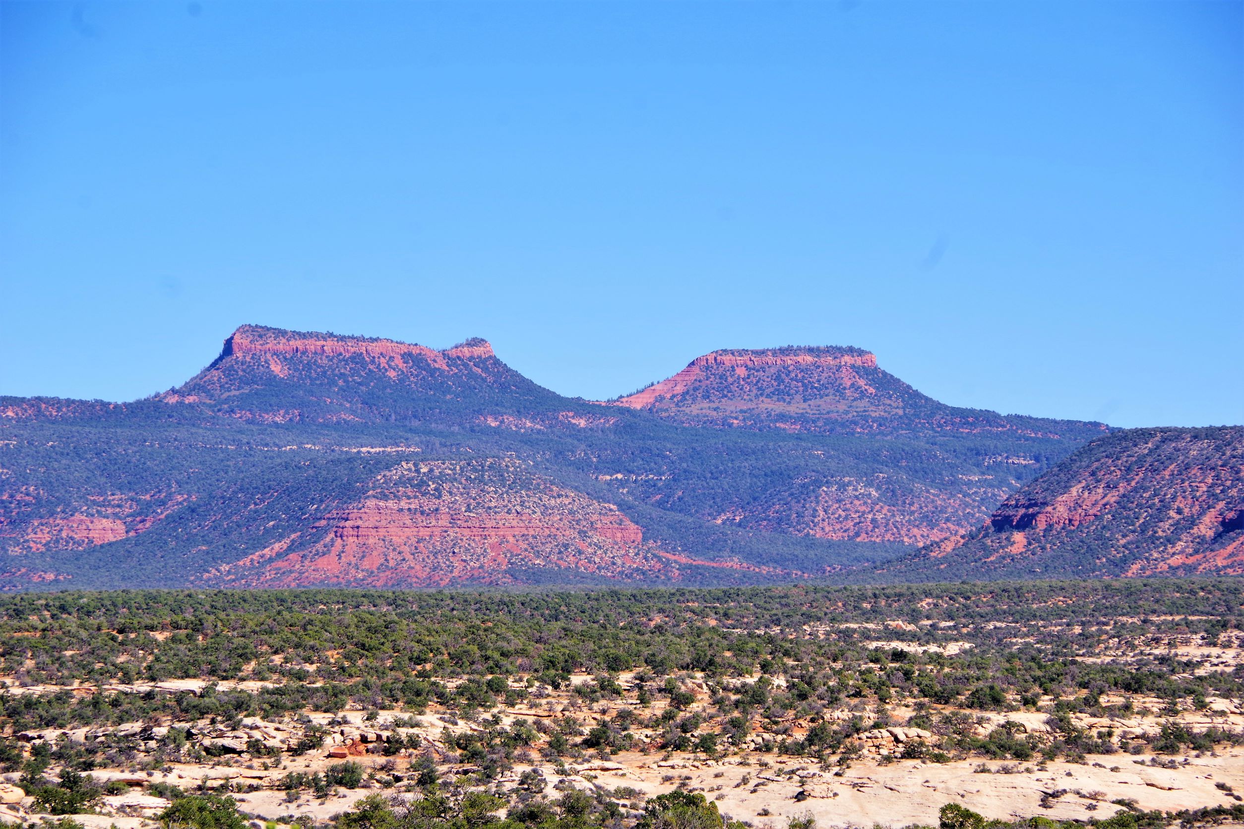
As we continued our drive around the park, we saw beautiful views of the Bear Ears buttes. The Bears Ears are sacred, beautiful, and iconic. The buttes are a local landmark, visible from the south and east some sixty miles away. The campground at Natural Bridges was full, so after our day of hiking to all the bridges, we left Natural Bridges National Monument and drove up the nearby Bears Ears Road – along which dispersed camping was scattered – that eventually runs between the two buttes. We found a fairly flat spot for our van where we could view the Bears Ears buttes again before going to sleep, surrounded by a beautiful and serene landscape.

The next morning, we descended down our mountain road and headed south across Cedar Mesa, on a regular-looking blacktop road. This stretch of highway, however, turned into a dirt road that drastically switched back and forth down the side of a cliff at an 11% grade. This part of the road, called Moki Dugway, has literally been carved out of the side of the cliff. The road was constructed in 1958 to provide a way to haul ore from the Happy Jack Mine on Cedar Mesa to the mill in Halchita, near Mexican Hat. Inasmuch as the road is considered pretty safe, I (Ren, not Rusty) had my eyes closed the whole way down, not caring to see the vast views of the valley below.
When we arrived at the bottom and drove into the Valley of the Gods, we were met with such beauty – a scenic sandstone valley with stunning geological forms. This area is sacred to the Navajo, whose mythology holds that these grand spires contain the spirits of Navajo warriors. We had only planned on staying one night, but we were so in awe of the area we stayed 4 nights, exploring and basking in the Valley’s wonders.


After we left the Valley of the Gods, we made a quick stop at Gooseneck State Park, which overlooks a deep meander of the San Juan River. Then we drove east on Hwy 163 paralleling the San Juan and the southern edge of Bears Ears National Monument. We stopped at the Sand Island Campground, which is located in the southwest corner of the Monument near Bluff, Utah. While there, we took two hikes to see nearby Petroglyph Panels. Most of the petroglyphs are from the early Basketmaker through Pueblo III eras, which range in time from 2500 to 800 years ago. The panels also have more recent Ute and Navajo rock art, which can be identified by their brighter carvings and location lower on the wall. There was also more contemporary graffiti (names and initials) scrawled on the rock, so some of the more accessible panels have been fenced off to prevent any more destruction.


In all, we spent a week and toured more than a 100 miles through the southern part of this huge National Monument, and saw and learned a lot. But these sacred lands of Bears Ears are so vast that a visitor could surely spend over month exploring here, and still never see it all. An exploration in the northern area, for example, would have included Canyonlands National Park and the Dark Canyon Wilderness. But we’ll save that for another trip!
Such beautiful country. It’s been over 50 years Since we were there but your pictures brought it all back. Thank you! Where are you headed next?
Thanks! So glad you liked the pictures. We remember all your stories about this area. We’re wintering over in Quartzsite, AZ and surrounding areas, BLMs, and Joshua Tree NP. Then east again, of course. But no schedule. Just whenever and wherever the wind blows us.