By Rusty
It was a year ago, while were hiking on the Colorado Trail, that the idea of hiking the Grand Canyon Rim-to-Rim-to-Rim in two days began to take shape in my head. I’d visited once before when I was only 12 years old, peering into the Canyon from the roadside overlooks, but never venturing down.

We’d tentatively planned for me to attempt this hike in mid- to late-September this year, but several factors pushed our plans back by several weeks. This was just as well since the Canyon was experiencing record high temps for this time of year, and at least 5 hikers died from heat-related issues with the last on September 6 when inner canyon temperatures exceeded 100 degrees.
We finally rolled into the Grand Canyon National Park on October 30. We were well-past peak season by now, and there were lots of empty camping spots in the very huge Mather Campground. More importantly, the temperatures had plummeted recently with high temperatures forecasted to be just in the mid-60s. We’d just gotten over several days with a serious chest cold too, with lots of coughing and fevers (we tested negative for Covid). I wasn’t 100 percent yet, but rain was coming soon, presenting me with a 2-day weather window. I didn’t want to postpone another year and decided I was strong enough to make the attempt.
Day One ~ Halloween
Sunrise will be at 6:50am today, and I’m hoping to hike down the South Rim, across the Canyon, and up the North Rim – 21.4 miles – before last light. The alarm rings out at 4:30am. I’m only half awake, as Ren brews some coffee and makes me eat some breakfast. We have time to talk again about what the next two days will bring. I’m taking my new Zoleo satellite communicator so Ren can track my progress.
It’s time to go. It’s chilly out, so I’m layered up in thermals, hat and gloves. My pack weighs only 20 lbs for this 2-day challenge, including water. Ren tells me to be careful and come back. I head out of the campground before 6am in the darkness, my headlamp lighting the way. There’s a shuttle/bus stop at the entrance to the campground that will take me to the Visitor Center and then the South Kaibab Trailhead. I miss a bus by mere seconds and have to wait a half hour for the next one, which finally put me at the trailhead well after sunrise… a late start!


After leaving the trailhead, I descend immediately along numerous, steep switchbacks down into the main part of the Canyon. The trail, carved into the cliff face, passes under Taki Point (one of the overlooks accessible by car) before dropping precipitously again along Cedar Ridge. The trail is wide enough for hikers and pack animals to pass, but it’s also deeply rutted and very steep and rocky in places.
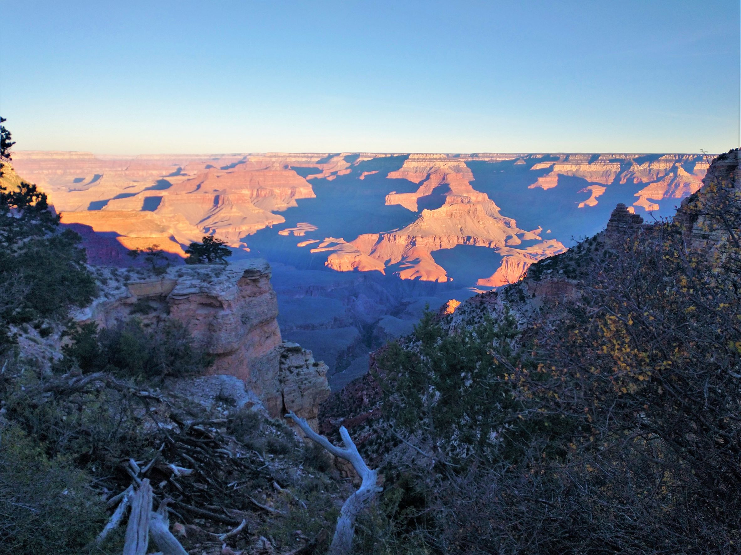
The prominent pinnacle of O’Neill Butte comes into view as the trail levels out a bit on a high flat ridge with stunning views of the Canyon and my first view of the Colorado River. After passing around the east slope of the Butte, the trail plunges down way too many painful switchbacks toward Tonto Plateau at Skeleton Point, which is the halfway point for my descent. From the South Rim to the Colorado River, the elevation drops nearly 5,000 ft over 6 miles, which is extremely steep by any measure. My hips are starting to ache, and an old IT Band injury is beginning to cause me problems.


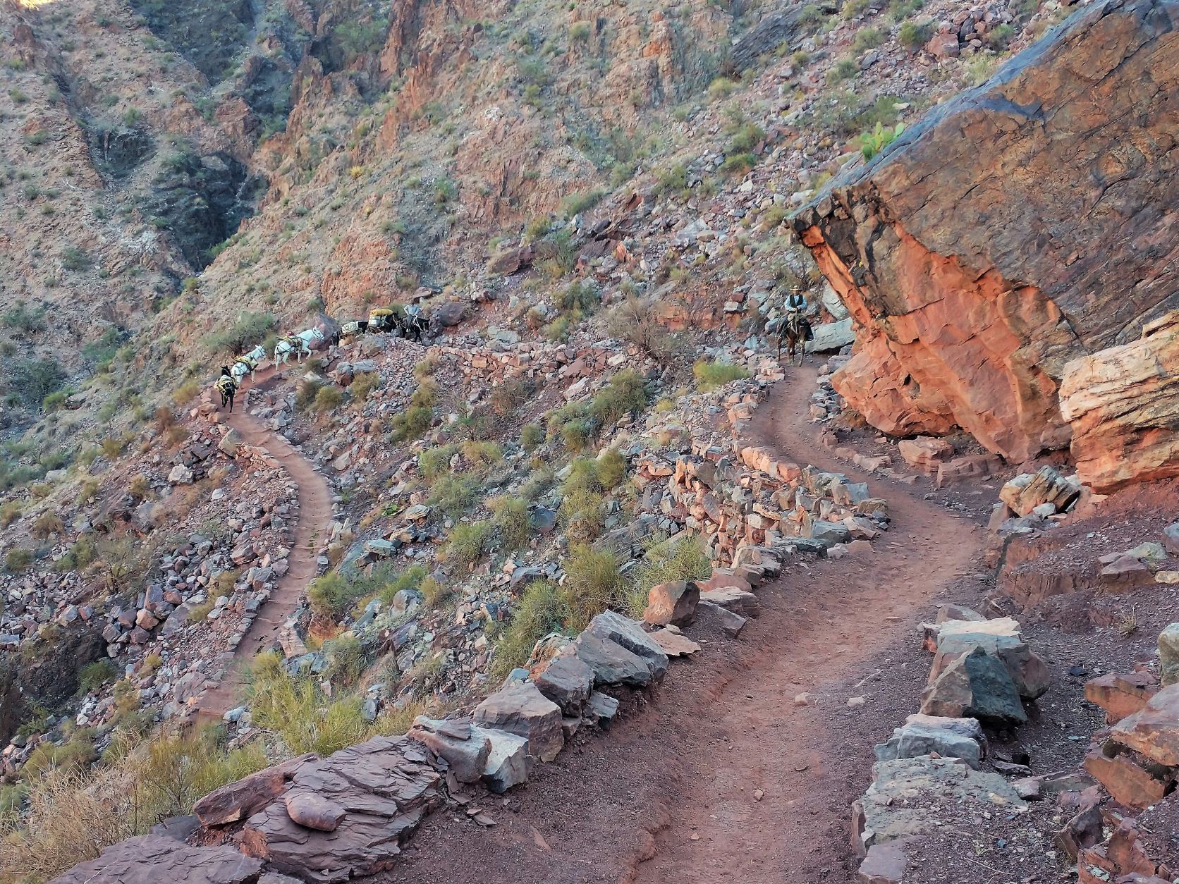

Another mile brings me to the Tipoff and the final, spectacular and winding descent into the Inner Gorge. Eventually, I spot the Kaibab Suspension Bridge where I’ll make my crossing… and a mule train is making its way back up the trail. There has been no water on this section, but with the cooler weather the 2.5 liters I started with has been plenty. Once across the bridge, I head west along the River for another mile to the Bright Angel Campground, bathrooms and potable water.
It is now 11:26 am, almost exactly 4 hours and 7 miles into my hike. I’m hot, already tired, and my knees are on fire. The North Rim is a thousand ft higher than the South Rim, but the North Kaibab Trail is spread out over 13.6 miles. I’m hoping the easier slope, along with a rest here, lots of Ibuprofen, lunch and getting rid of some layers of clothing will improve my pace and help my knees. A fat squirrel pesters me for some crumbs.
The trail is much easier here as it follows the Bright Angel Creek out of the Inner Gorge and past Phantom Ranch. The Creek, which provides the drinking water source for all of the campgrounds and the entire Grand Canyon Village, has dug its own deep serpentine canyon here. At certain points, the canyon walls are nearly vertical, forcing the trail to cross the Creek on foot bridges to find a flatter spot. I climb only 1,600 ft over the next 7 miles or so before I get to the empty Cottonwood Campground, potable water and another rest. My knees still hurt, but they’re not getting any worse.
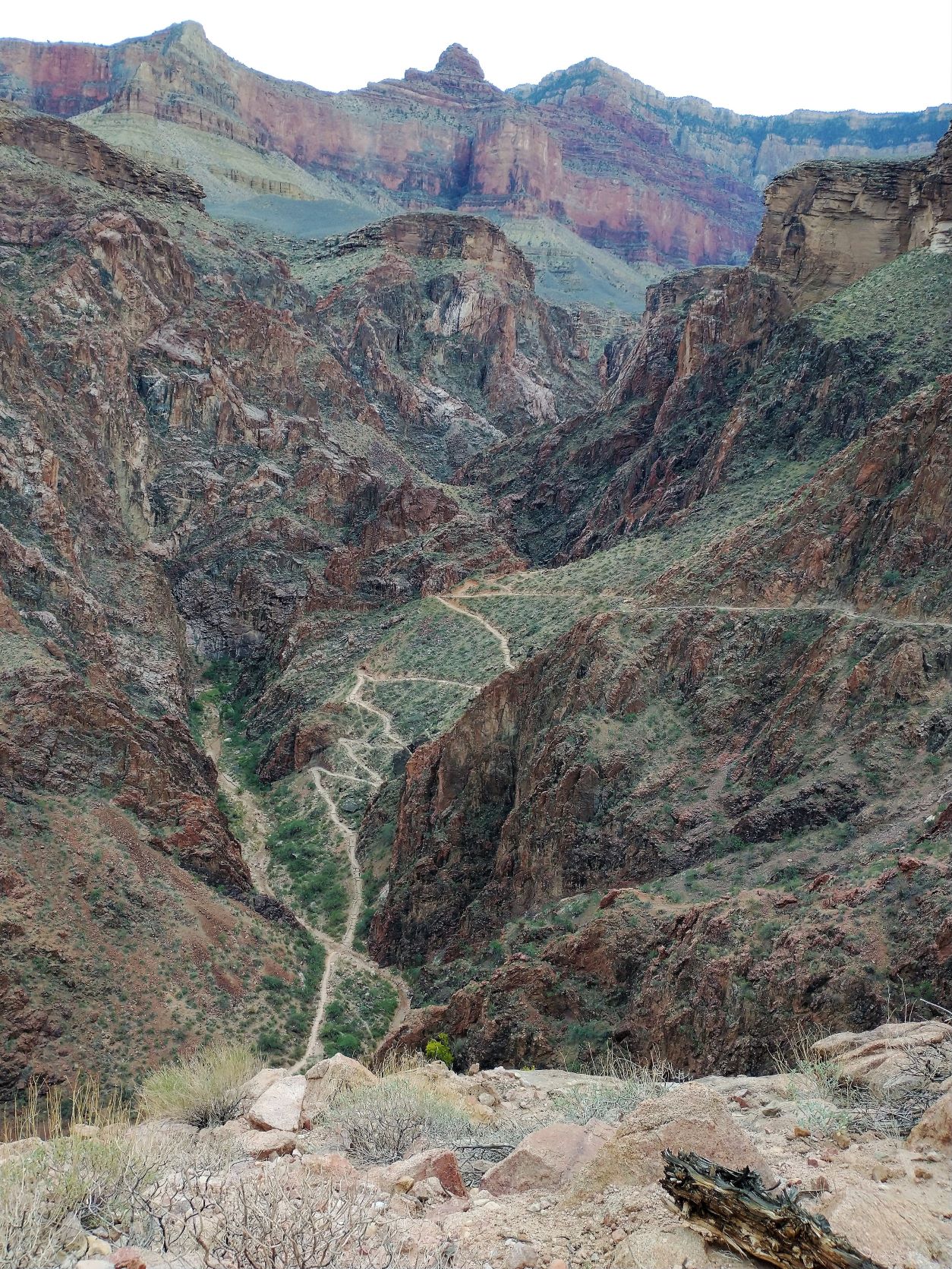
At about 9 miles into the North Kaibab Trail, I leave the Bright Angel Canyon and start following the southern slope of the Roaring Springs Canyon up to the North Rim. I see a waterfall – the Roaring Springs – on the other side of the canyon, gushing directly out of the face of the cliff. But it’s late in the season and two more waterfalls that should be flowing are not roaring today. The trail gets very steep here with more rocky switchbacks. I have another 4.6 miles to hike and about 3,200 ft to climb. The sun is getting lower in the sky, lighting up the distant canyon walls but leaving me mostly in shadow.


At about 10 miles, I encounter a trail guide leading 8 Pakistani women hiking down to Cottonwood. I’ve seen at least 30 hikers, and a few trail runners, today. I can’t imagine how many people are on this trail during peak season.
Another half mile and I cross the Redwall Bridge, suspended by cables across the Roaring Springs Canyon and start up an even steeper section of the trail. During the summer months, the Park Service discourages day-hikers from going any further down into the Canyon since the climb back to the Rim from here is so hard.
The trail hugs the side of the canyon wall. It’s getting late. The temperature is starting to drop. And, my knees won’t let me pick up my pace. There is a rest area at the Supai Tunnel, about 2 miles from the top, but the water here has been turned off. I continue without stopping. It’s cool now, and getting colder by the minute. Even though I’m hiking hard, I have to add back some layers to stay warm enough. I have maybe an hour of daylight left.
The sun finally sets just before I get to Coconino Overlook, less than a mile from the top. I put on my headlamp and hike on. I’m exhausted. The last 3 miles of the North Kaibab Trail have been some of the hardest I’ve ever hiked. A half hour later I reach the North Kaibab Trailhead. It’s dark and I’m a little disoriented. It’s a half mile to the Campground here, but the Ken Patrick Trail, that follows the rim east, is closer. I hike into the forest a ways and find a flat and secluded spot to set up my tent. I message Ren that I made it to the North Rim and that I’m safe.
It’s supposed to drop to near freezing temps tonight. I pull everything inside the tent with me and snuggle deep into my sleeping bag and wait for sleep.
Day Two ~ November 1
Set my phone alarm for 5:30 am. It’s dark and cold, but above freezing. I climb out of my sleeping bag still in yesterday’s hiking clothes and pack up by my headlamp. I start my Zoleo tracking and head back to the trailhead. It’s 6:26 am and there’s just the bit of light in the sky casting the trees in silhouette. I start back down the North Kaibab Trail and my knees are stiff already hurting, slowing my pace.
I reach Redwall Bridge, 2.6 miles down, after an hour and a half… very slow! Two female trail runners pass me by. Just past the bridge, there’s a long section of the trail that’s been blasted out of the limestone cliff face. From the expansive vistas to the engineering feat of building this trail at all, it’s truly inspiring in every way. I continue down past the Roaring Springs to meet up again with the Bright Angel Creek.


The trail thankfully flattens out here and my next 8.5 miles is easier and faster as I retrace yesterday’s steps back to the Bright Angel Campground and the Colorado River. However, I’m not making my way to the South Rim via the South Kaibab Trail today, opting instead to use the longer and more popular Bright Angel Trail. This will make today’s hike 23.5 miles long, but I want to see a different part of the Canyon and I’m hoping my earlier start will get me to the South Rim by dark.
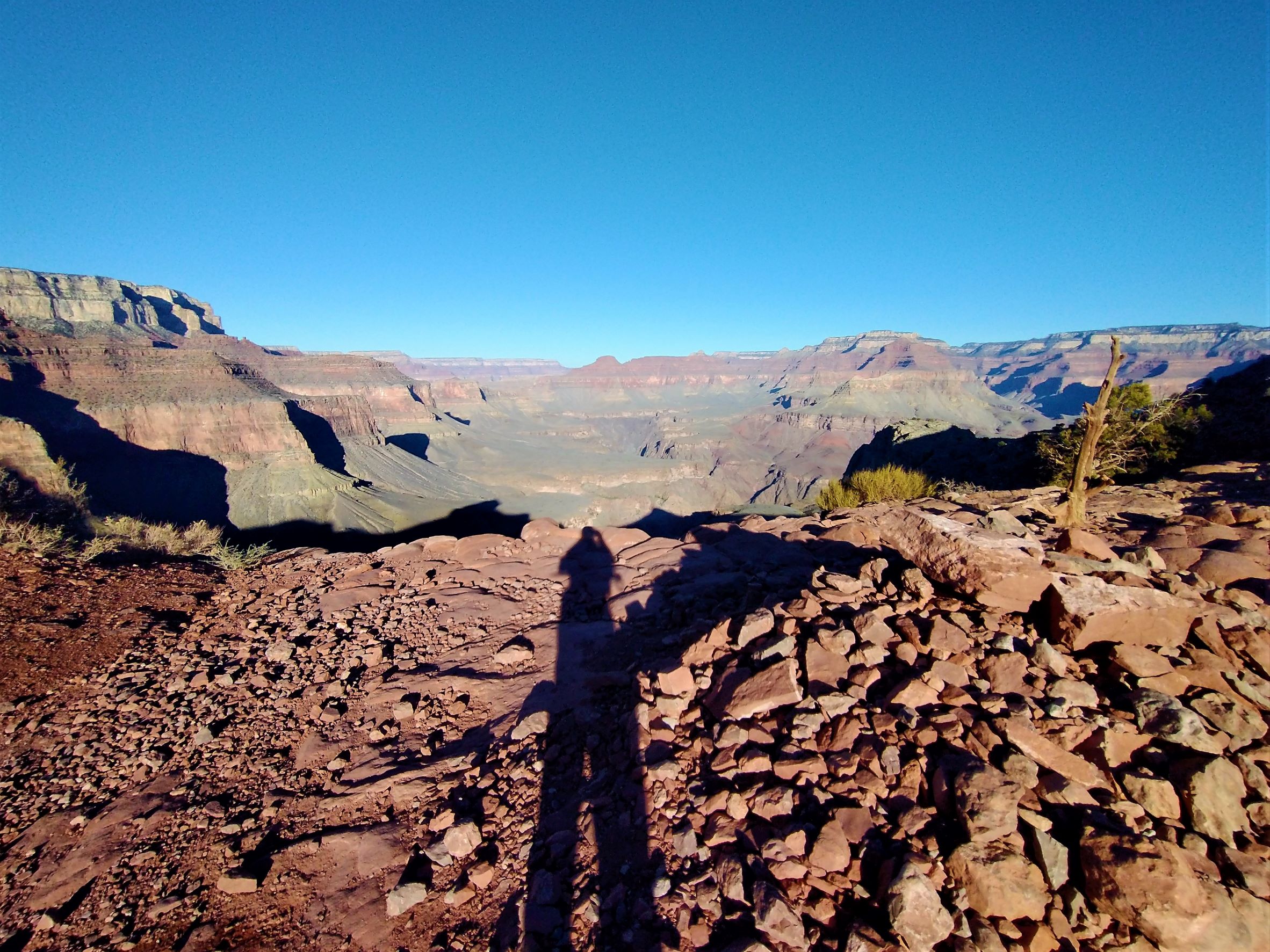
I cross the Silver Bridge just down river from the Bright Angel Campground and follow the River Trail west along a very loose, sandy trail for about a mile. There is a small beach there and a rest house where the Bright Angel Trail heads south up a shallow side canyon along Pipe Creek. I pass another mule train, led by rangers resupplying one of the ranger stations in the Canyon. Another mile brings me to the Devil’s Corkscrew and a series of steep switchbacks I have to climb. It’s a thousand feet up over the next mile to Plateau Point where the trail enters the much bigger Garden Creek Canyon and a massive fault line.
The trail flattens here somewhat as it follows Garden Creek. This is something of an oasis, with more trees, reeds and other water-loving plants hugging the creek’s banks. I come across a group of mule deer munching on the grasses. Eventually, I get to Indian Garden Campground, with 4.5 miles to go to the rim. It’s already a quarter after 4, but I stop anyway to rest, water-up and eat something. Two more trail runners come by and take a break with me. They’re trying to run Rim-to-Rim-to-Rim in 14 hours. They started at the South Kaibab Trailhead this morning at 4am. I’m impressed and a little humbled.


I continue on and start encountering more and more hikers heading to the South Rim like me. After a mile, the trails turns suddenly steeper. More than half of the 5,000 elevation change on the Bright Angel Trail happens in the next 3.5 miles. There’s a rest house 3 miles from the rim and another at 1.5 miles. It’s slow going, and I stop frequently to catch my breath and stretch the sore tendons in my legs.
The sun is near the horizon, lighting up the canyon walls in soft orange and red hues. It’s truly breath-taking. With about a mile to go, the last of the light fades and I put on my headlamp to light the path in front of me, and the dropoff beside me. Other hikers are doing the same, and I see spots of light behind me and in front crawling along the trail.
I’m exhausted. As I near the top, I see a dark form on the trail ahead. Then some rocks tumble from above onto the trail around me. I look up and illuminate two mountain goats clinging to the canyon wall above, nibbling on grass. The rare encounter energizes me and I climb the last few hundred feet without trouble.


It’s about 6:20 pm when I make the summit and the trailhead. I quickly look for the bus stop that will take me back to Mather Campground and Ren. The last bus leaves just an hour past sundown. I just make it. Sitting in the bus, I ponder my hike and how much harder it was than I predicted. I’m glad it’s over, but I’m also glad that I did it.